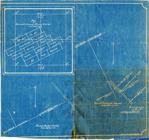
Map 115 -- Mammoth Group of Mining Claims
Detail

Location
Map 115 -- Mammoth Group of Mining Claims |
Detail |
|
|
|
|
Location |
|
|
|
Order |
| SCALE | 12000/600 | DATE | 1929 |
|---|---|---|---|
| AUTHOR | Wood, Homer R. | PUBLISHER | Wood, Homer R. |
| WIDTH X HEIGHT | 16 x 14 in. | FORMAT | blueprint |
| PIXELS | 4668 x 4280 | RESOLUTION | 300 dpi |
| DIGITAL FILE | map0115.tif | SIZE & COLOR | 57 Mb RGB |
| ACCESSION NO. | 97.042 | CALL NO. | Map #115 |
| LOCATION | Lawler collection |
|
Includes maps of Anchor tunnel and Mammoth tunnel at 50 ft. to 1 inch. Mammoth group includes: Anchor, Ibex, Mammoth, Mesa View, Monitor, Olympia, Oregon, Osage, Philadelphia, Pilot Knob, Tango, Wade Hampton, Wyandotte and Wyoming mining claims. (Lawler collection) |
Museum | Archives | Maps |
|