Map 58a -- The Grand Canyon of the Colorado River, Arizona
Detail
Location
Map 58a -- The Grand Canyon of the Colorado River, Arizona |
Detail |
|
|
|
|
Location |
|
|
|
Order |
| SCALE | c10000 | DATE | 1892 |
|---|---|---|---|
| AUTHOR | Baumann, Jules | PUBLISHER | Aug. Gast Bank Note Co. |
| WIDTH X HEIGHT | 39 x 25 in. | FORMAT | |
| PIXELS | 11679 x 7509 | RESOLUTION | 300 dpi |
| DIGITAL FILE | map0058a.tif | SIZE & COLOR | 250 Mb RGB |
| ACCESSION NO. | CALL NO. | Map #58a | |
| LOCATION |
|
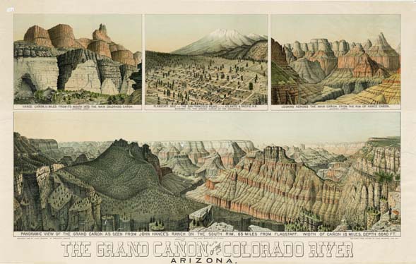
Four sketches in June 1891: Lower panel: Panoramic view of the Grand
Canyon as seen from John Hance's Ranch on the South Rim; Top left: Hance
Canyon, 1.5 miles from its mouth into the main Colorado canyon, looking
east; Top right: Looking across the main canyon from the rim of Hance
Canyon, looking north; Top center: Flagstaff and the San Francisco Peaks. |
Museum | Archives | Maps |
|