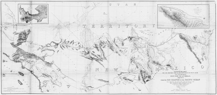
Map 54 - Surveys for a Railroad Route from the Rio Grande to the Pacific Ocean
Detail
Location

Map 54 - Surveys for a Railroad Route from the Rio Grande to the Pacific Ocean |
|
|
|
Detail |
Location |
|
|
Order |
|
| SCALE | 950000 | DATE | 1861 |
|---|---|---|---|
| AUTHOR | Hoffman, J.D. | PUBLISHER | U.S. War Department |
| WIDTH X HEIGHT | 50 x 22 in | FORMAT | |
| PIXELS | 15317 x 6792 | RESOLUTION | 300 dpi |
| DIGITAL FILE | map0054.tif | SIZE & COLOR | 99 Mb grayscale |
| ACCESSION NO. | CALL NO. | Map #54 | |
| LOCATION |
|
From explorations and surveys by Lieut. A.W. Whipple, Topographical Engineer, 1853-4. Includes insets of Aztec Pass and Campbell's Pass. Map indicates wagon
trails, See also Map #90 Preliminary map of the western
portion of the reconnaissance and survey for a Pacific rail road route
near the 35th par.
|
Museum | Archives | Maps |
|